
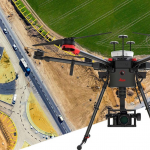
UAV Systems
Complete UAV solution for surveying and construction enables fast and flexible data collection for efficient project delivery providing you quick access to critical information to perform your day-to-day work.
- Description
Description
INTENDED USE
As a complete workflow management solution, UAV technology allows you to process and analyse millions of data points gathered from above and to visualise the data to provide actionable information. UAV data can be combined with existing survey technologies, such as TPS, GPS, and laser scanning providing a more complete set of information. By taking only minutes to survey a site, UAVs enable the completion of projects at a lower cost and with fewer staff.
ADVANTAGES
The Leica Aibot provides a complete UAV solution for surveying, mapping and construction. It enables fast data collection and an easy workflow that guides you through your project lifecycle providing you quick access to critical information to perform your day-to-day work.
SPECIFICATION
Please refer to the product catalog.


